Freemansburg, Pennsylvania
Freemansburg is a borough in Northampton County, Pennsylvania. The population of Freemansburg was 2,875 as of the 2020 census. The Lehigh River, a 109-mile-long (175 km) tributary of the Delaware River, flows through Freemansburg.
Borough of Freemansburg | |
|---|---|
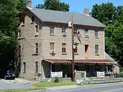 Jacob Freeman House in Freemansburg in July 2015 | |
 Seal | |
 Location of Freemansburg in Northampton County, Pennsylvania (left) and of Northampton County in Pennsylvania (right) | |
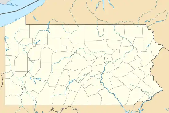 Freemansburg Location of Freemansburg in Pennsylvania  Freemansburg Freemansburg (the United States) | |
| Coordinates: 40°37′38″N 75°20′23″W | |
| Country | |
| State | |
| County | Northampton |
| Government | |
| • Mayor | Donald Lasso |
| Area | |
| • City | 0.74 sq mi (1.93 km2) |
| • Land | 0.70 sq mi (1.81 km2) |
| • Water | 0.05 sq mi (0.12 km2) |
| Elevation | 325 ft (99 m) |
| Population | |
| • City | 2,875 |
| • Density | 4,124.82/sq mi (1,591.51/km2) |
| • Metro | 865,310 (US: 68th) |
| Time zone | UTC-5 (EST) |
| • Summer (DST) | UTC-4 (EDT) |
| ZIP Code | 18017 |
| Area codes | 610 and 484 |
| FIPS code | 42-27760 |
| Primary airport | Lehigh Valley International Airport |
| Major hospital | Lehigh Valley Hospital–Cedar Crest |
| School district | Bethlehem Area |
| Website | www |
Freemansburg is part of the Lehigh Valley metropolitan area, which had a population of 861,899 and was the 68th-most populous metropolitan area in the U.S. as of the 2020 census.
History
Freemansburg was named for Jacob Freeman.[3]
Geography
Freemansburg is located at 40°37′38″N 75°20′23″W (40.627348, -75.339815).[4] According to the U.S. Census Bureau, the borough has a total area of 0.8 square miles (2.1 km2), of which 0.7 square miles (1.8 km2) is land and 0.04 square miles (0.10 km2) (5.26%) is water.
Transportation
As of 2018, there were 10.24 miles (16.48 km) of public roads in Freemansburg, of which 1.88 miles (3.03 km) were maintained by the Pennsylvania Department of Transportation (PennDOT) and 8.36 miles (13.45 km) were maintained by the borough.[5]
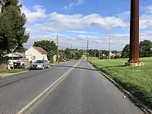
No numbered highways pass through Freemansburg directly. Main thoroughfares traversing the borough include Freemansburg Avenue, Washington Street, Main Street, Market Street and Cambria Street.
Demographics
| Census | Pop. | Note | %± |
|---|---|---|---|
| 1860 | 649 | — | |
| 1870 | 643 | −0.9% | |
| 1880 | 634 | −1.4% | |
| 1890 | 615 | −3.0% | |
| 1900 | 596 | −3.1% | |
| 1910 | 867 | 45.5% | |
| 1920 | 1,203 | 38.8% | |
| 1930 | 1,777 | 47.7% | |
| 1940 | 1,728 | −2.8% | |
| 1950 | 1,739 | 0.6% | |
| 1960 | 1,652 | −5.0% | |
| 1970 | 1,681 | 1.8% | |
| 1980 | 1,879 | 11.8% | |
| 1990 | 1,946 | 3.6% | |
| 2000 | 1,897 | −2.5% | |
| 2010 | 2,636 | 39.0% | |
| 2020 | 2,875 | 9.1% | |
| Sources:[6][7][8][2] | |||
As of 2010, the population has increased 39.0% from 2000 to 2010, which there were 2,636 people in the borough. The 2010 racial makeup of the borough has dramatically changed as well. In 2010, the borough was 59.7% (Whites), 12.7% (African Americans), 0.3% (Native Americans), 0.8% (Asians), 0.04% (Pacific Islander), and 2.0% from two or more races. Hispanic or Latino of any race were 24% of the population.
There were 687 households, out of which 34.4% had children under the age of 18 living with them, 54.4% were married couples living together, 11.5% had a female householder with no husband present, and 28.2% were non-families. 23.3% of all households were made up of individuals, and 8.4% had someone living alone who was 65 years of age or older. The average household size was 2.64 and the average family size was 3.06.
In the borough, the population was spread out, with 24.8% under the age of 18, 9.5% from 18 to 24, 34.2% from 25 to 44, 19.0% from 45 to 64, and 12.5% who were 65 years of age or older. The median age was 36 years. For every 100 females there were 101.8 males. For every 100 females age 18 and over, there were 98.7 males. The median income for a household in the borough was $44,297, and the median income for a family was $48,333. Males had a median income of $31,994 versus $24,853 for females. The per capita income for the borough was $17,983. About 6.7% of families and 9.4% of the population were below the poverty line, including 11.0% of those under age 18 and 6.9% of those age 65 or over.
Public education
The borough is served by the Bethlehem Area School District.
References
- "ArcGIS REST Services Directory". United States Census Bureau. Retrieved October 12, 2022.
- "Census Population API". United States Census Bureau. Retrieved Oct 12, 2022.
- Gannett, Henry (1905). The Origin of Certain Place Names in the United States. Govt. Print. Off. pp. 132.
- "US Gazetteer files: 2010, 2000, and 1990". United States Census Bureau. 2011-02-12. Retrieved 2011-04-23.
- "Freemansburg Borough map" (PDF). PennDOT. Retrieved March 16, 2023.
- "Census of Population and Housing". U.S. Census Bureau. Retrieved 11 December 2013.
- "U.S. Census website". United States Census Bureau. Retrieved 2008-01-31.
- "Incorporated Places and Minor Civil Divisions Datasets: Subcounty Resident Population Estimates: April 1, 2010 to July 1, 2012". Population Estimates. U.S. Census Bureau. Archived from the original on 11 June 2013. Retrieved 11 December 2013.
External links
Municipalities and communities of Northampton County, Pennsylvania, United States | ||
|---|---|---|
| Region |  | |
| Cities | ||
| Boroughs | ||
| Townships | ||
| CDPs | ||
| Other communities | ||
| Notable people | ||
| Culture | ||
| Footnotes | ‡This populated place also has portions in an adjacent county or counties | |