Donggang, Liaoning
Donggang (simplified Chinese: 东港; traditional Chinese: 東港; pinyin: Dōnggǎng; lit. 'Eastern Port') is a city in the southeast of Liaoning Province in Northeast China. Situated on the coast of the Yellow Sea at the mouth of the Yalu River, it is located near the maritime border with North Korea. Administratively, it is a county-level city of Dandong, the downtown of which lies 35 kilometres (22 mi) to the northeast.
Donggang
东港市 | |
|---|---|
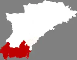 Location in Dandong | |
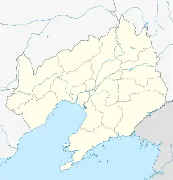 Donggang Location in Liaoning | |
| Coordinates: 39°52′N 124°09′E | |
| Country | People's Republic of China |
| Province | Liaoning |
| Prefecture-level city | Dandong |
| Area | |
| • County-level city | 2,398.0 km2 (925.9 sq mi) |
| • Urban | 126.00 km2 (48.65 sq mi) |
| Population (2017)[1] | |
| • County-level city | 609,000 |
| • Density | 250/km2 (660/sq mi) |
| • Urban | 170,400 |
| Time zone | UTC+8 (China Standard) |
Administrative Divisions
There are three subdistricts, 14 towns, and one ethnic township under the city's administration.[2]
Subdistricts: Dadong Subdistrict (大东街道), Xincheng Subdistrict (新城街道), Xinxing Subdistrict (新兴街道)
Towns: Gushan (Kushan) (孤山镇), Qianyang (前阳镇), Changshan (长山镇), Beijingzi (北井子镇), Yiquan (椅圈镇), Huangtukan (Hwangtukan) (黄土坎镇), Majiadian (马家店镇), Pusamiao (菩萨庙镇), Longwangmiao (龙王庙镇), Xiaodianzi (小甸子镇), Chang'an (长安镇), Xinnong (新农镇), Heigou (黑沟镇), Shizijie (十字街镇)
The only township is Helong Manchu Ethnic Township (合隆满族乡)
Climate
| Climate data for Donggang (1981−2010) | |||||||||||||
|---|---|---|---|---|---|---|---|---|---|---|---|---|---|
| Month | Jan | Feb | Mar | Apr | May | Jun | Jul | Aug | Sep | Oct | Nov | Dec | Year |
| Record high °C (°F) | 9.5 (49.1) |
14.7 (58.5) |
20.2 (68.4) |
24.4 (75.9) |
29.7 (85.5) |
32.5 (90.5) |
34.6 (94.3) |
34.1 (93.4) |
31.3 (88.3) |
28.7 (83.7) |
19.3 (66.7) |
11.6 (52.9) |
34.6 (94.3) |
| Average high °C (°F) | −2.2 (28.0) |
1.5 (34.7) |
6.9 (44.4) |
13.8 (56.8) |
19.2 (66.6) |
23.3 (73.9) |
26.2 (79.2) |
27.6 (81.7) |
24.0 (75.2) |
17.2 (63.0) |
8.0 (46.4) |
0.3 (32.5) |
13.8 (56.9) |
| Daily mean °C (°F) | −7.2 (19.0) |
−3.6 (25.5) |
2.2 (36.0) |
9.2 (48.6) |
15.0 (59.0) |
19.7 (67.5) |
23.1 (73.6) |
23.9 (75.0) |
18.9 (66.0) |
11.7 (53.1) |
3.1 (37.6) |
−4.4 (24.1) |
9.3 (48.8) |
| Average low °C (°F) | −11.5 (11.3) |
−8.0 (17.6) |
−2.0 (28.4) |
4.7 (40.5) |
11.1 (52.0) |
16.5 (61.7) |
20.5 (68.9) |
20.6 (69.1) |
14.3 (57.7) |
6.7 (44.1) |
−1.0 (30.2) |
−8.2 (17.2) |
5.3 (41.6) |
| Record low °C (°F) | −25.5 (−13.9) |
−23.9 (−11.0) |
−11.7 (10.9) |
−4.6 (23.7) |
2.8 (37.0) |
9.4 (48.9) |
15.4 (59.7) |
11.8 (53.2) |
3.4 (38.1) |
−4.6 (23.7) |
−13.6 (7.5) |
−23.5 (−10.3) |
−25.5 (−13.9) |
| Average precipitation mm (inches) | 7.4 (0.29) |
11.2 (0.44) |
21.0 (0.83) |
44.7 (1.76) |
73.7 (2.90) |
105.5 (4.15) |
219.2 (8.63) |
209.6 (8.25) |
86.8 (3.42) |
46.0 (1.81) |
26.5 (1.04) |
13.3 (0.52) |
864.9 (34.04) |
| Average relative humidity (%) | 59 | 59 | 64 | 69 | 76 | 84 | 89 | 85 | 78 | 71 | 65 | 62 | 72 |
| Source: China Meteorological Data Service Center[3] | |||||||||||||
References
- Ministry of Housing and Urban-Rural Development, ed. (2019). China Urban Construction Statistical Yearbook 2017. Beijing: China Statistics Press. p. 50. Retrieved 11 January 2020.
- 丹东市-行政区划网
- 中国地面气候标准值月值(1981-2010) (in Simplified Chinese). China Meteorological Data Service Center. Retrieved 24 September 2022.
External links