Clayton railway station, Melbourne
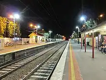
Clayton railway station is a commuter railway station located in the suburb of Clayton, in the south-eastern suburbs of Melbourne, Victoria, Australia.[5] The station originally opened in 1880 as "Clayton's Road".[6] It did not receive its current name until 1890.[6] The station consists of a single island platform connected to the station concourse on Clayton Road via escalators, lifts and a staircase.[5]
Clayton | |||||||||||||||||||||||||||||||||||||||||||||||||||||||||||||||||||||||||||||
|---|---|---|---|---|---|---|---|---|---|---|---|---|---|---|---|---|---|---|---|---|---|---|---|---|---|---|---|---|---|---|---|---|---|---|---|---|---|---|---|---|---|---|---|---|---|---|---|---|---|---|---|---|---|---|---|---|---|---|---|---|---|---|---|---|---|---|---|---|---|---|---|---|---|---|---|---|---|
| PTV commuter and regional rail station | |||||||||||||||||||||||||||||||||||||||||||||||||||||||||||||||||||||||||||||
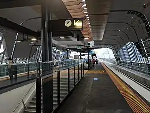 South-east bound view from Platform 1 April 2018 | |||||||||||||||||||||||||||||||||||||||||||||||||||||||||||||||||||||||||||||
| General information | |||||||||||||||||||||||||||||||||||||||||||||||||||||||||||||||||||||||||||||
| Location | 274 Clayton Road,[1] Clayton, Victoria 3168 City of Monash Australia | ||||||||||||||||||||||||||||||||||||||||||||||||||||||||||||||||||||||||||||
| Coordinates | 37°55′28″S 145°07′12″E | ||||||||||||||||||||||||||||||||||||||||||||||||||||||||||||||||||||||||||||
| Owned by | VicTrack | ||||||||||||||||||||||||||||||||||||||||||||||||||||||||||||||||||||||||||||
| Operated by | Metro Trains | ||||||||||||||||||||||||||||||||||||||||||||||||||||||||||||||||||||||||||||
| Line(s) | |||||||||||||||||||||||||||||||||||||||||||||||||||||||||||||||||||||||||||||
| Distance | 20.51 kilometres from Southern Cross | ||||||||||||||||||||||||||||||||||||||||||||||||||||||||||||||||||||||||||||
| Platforms | 2 (1 island) | ||||||||||||||||||||||||||||||||||||||||||||||||||||||||||||||||||||||||||||
| Tracks | 2 | ||||||||||||||||||||||||||||||||||||||||||||||||||||||||||||||||||||||||||||
| Train operators | |||||||||||||||||||||||||||||||||||||||||||||||||||||||||||||||||||||||||||||
| Connections | 6 bus routes | ||||||||||||||||||||||||||||||||||||||||||||||||||||||||||||||||||||||||||||
| Construction | |||||||||||||||||||||||||||||||||||||||||||||||||||||||||||||||||||||||||||||
| Structure type | Elevated | ||||||||||||||||||||||||||||||||||||||||||||||||||||||||||||||||||||||||||||
| Parking | 260 spaces | ||||||||||||||||||||||||||||||||||||||||||||||||||||||||||||||||||||||||||||
| Bicycle facilities | 12 racks | ||||||||||||||||||||||||||||||||||||||||||||||||||||||||||||||||||||||||||||
| Accessible | Yes—step free access | ||||||||||||||||||||||||||||||||||||||||||||||||||||||||||||||||||||||||||||
| Other information | |||||||||||||||||||||||||||||||||||||||||||||||||||||||||||||||||||||||||||||
| Status | Operational, premium station | ||||||||||||||||||||||||||||||||||||||||||||||||||||||||||||||||||||||||||||
| Station code | CLA | ||||||||||||||||||||||||||||||||||||||||||||||||||||||||||||||||||||||||||||
| Fare zone | Myki Zone 2 | ||||||||||||||||||||||||||||||||||||||||||||||||||||||||||||||||||||||||||||
| Website | Public Transport Victoria | ||||||||||||||||||||||||||||||||||||||||||||||||||||||||||||||||||||||||||||
| History | |||||||||||||||||||||||||||||||||||||||||||||||||||||||||||||||||||||||||||||
| Opened | 6 January 1880 | ||||||||||||||||||||||||||||||||||||||||||||||||||||||||||||||||||||||||||||
| Rebuilt | 16 April 2018 (LXRP) | ||||||||||||||||||||||||||||||||||||||||||||||||||||||||||||||||||||||||||||
| Electrified | December 1922 (1500 V DC overhead) | ||||||||||||||||||||||||||||||||||||||||||||||||||||||||||||||||||||||||||||
| Previous names | Clayton's Road (1880-1891) | ||||||||||||||||||||||||||||||||||||||||||||||||||||||||||||||||||||||||||||
| Passengers | |||||||||||||||||||||||||||||||||||||||||||||||||||||||||||||||||||||||||||||
| 2005–2006 | 1,047,064[2] | ||||||||||||||||||||||||||||||||||||||||||||||||||||||||||||||||||||||||||||
| 2006–2007 | 1,185,964[2] | ||||||||||||||||||||||||||||||||||||||||||||||||||||||||||||||||||||||||||||
| 2007–2008 | 1,373,910[2] | ||||||||||||||||||||||||||||||||||||||||||||||||||||||||||||||||||||||||||||
| 2008–2009 | 1,720,328[3] | ||||||||||||||||||||||||||||||||||||||||||||||||||||||||||||||||||||||||||||
| 2009–2010 | 1,749,175[3] | ||||||||||||||||||||||||||||||||||||||||||||||||||||||||||||||||||||||||||||
| 2010–2011 | 1,711,528[3] | ||||||||||||||||||||||||||||||||||||||||||||||||||||||||||||||||||||||||||||
| 2011–2012 | 1,721,420[3] | ||||||||||||||||||||||||||||||||||||||||||||||||||||||||||||||||||||||||||||
| 2012–2013 | Not measured[3] | ||||||||||||||||||||||||||||||||||||||||||||||||||||||||||||||||||||||||||||
| 2013–2014 | 1,495,192[3] | ||||||||||||||||||||||||||||||||||||||||||||||||||||||||||||||||||||||||||||
| 2014–2015 | 1,618,549[2] | ||||||||||||||||||||||||||||||||||||||||||||||||||||||||||||||||||||||||||||
| 2015–2016 | 1,944,934[3] | ||||||||||||||||||||||||||||||||||||||||||||||||||||||||||||||||||||||||||||
| 2016–2017 | 1,803,536[3] | ||||||||||||||||||||||||||||||||||||||||||||||||||||||||||||||||||||||||||||
| 2017–2018 | 1,432,893[3] | ||||||||||||||||||||||||||||||||||||||||||||||||||||||||||||||||||||||||||||
| 2018–2019 | 1,612,702[3] | ||||||||||||||||||||||||||||||||||||||||||||||||||||||||||||||||||||||||||||
| 2019–2020 | 1,388,700[3] | ||||||||||||||||||||||||||||||||||||||||||||||||||||||||||||||||||||||||||||
| 2020–2021 | 796,650[3] | ||||||||||||||||||||||||||||||||||||||||||||||||||||||||||||||||||||||||||||
| 2021–2022 | 853,500[4] | ||||||||||||||||||||||||||||||||||||||||||||||||||||||||||||||||||||||||||||
| Services | |||||||||||||||||||||||||||||||||||||||||||||||||||||||||||||||||||||||||||||
| |||||||||||||||||||||||||||||||||||||||||||||||||||||||||||||||||||||||||||||
| Future services | |||||||||||||||||||||||||||||||||||||||||||||||||||||||||||||||||||||||||||||
| |||||||||||||||||||||||||||||||||||||||||||||||||||||||||||||||||||||||||||||
| Official name | Clayton Railway Station | ||||||||||||||||||||||||||||||||||||||||||||||||||||||||||||||||||||||||||||
| Criteria | C, D, E | ||||||||||||||||||||||||||||||||||||||||||||||||||||||||||||||||||||||||||||
| Designated | 20 August 1982 | ||||||||||||||||||||||||||||||||||||||||||||||||||||||||||||||||||||||||||||
| Reference no. | H1667[1] | ||||||||||||||||||||||||||||||||||||||||||||||||||||||||||||||||||||||||||||
| |||||||||||||||||||||||||||||||||||||||||||||||||||||||||||||||||||||||||||||
Clayton station is currently served by the Pakenham and Cranbourne lines which are both part of the Melbourne railway network. Additionally, the station is also served by the Gippsland line, which is a part of the Victorian regional railway network.[7] Additionally, the station is served by eight bus routes, including SmartBus route 703.[5] The station is approximately 17 kilometres (11.8 mi), or around a 33 minute train ride away, from Flinders Street.[8]
Description

Clayton railway station is located in the suburb of Clayton. On the north side of the station is Carnish Road, and Clayton Road is to the west. The station is owned by VicTrack, a state government agency, and is operated by Metro Trains Melbourne.[5] The station is approximately 19 kilometres (11.8 mi), or around a 33 minute train ride away, from Flinders Street.[8]
Clayton station consists of a single island platform which is located above the road, and is connected to Clayton Road through either a lift and an escalator. The length of the platform is approximately 160 metres (520 ft), long enough for a Metro Trains' 7-car HCMT.[5]
The main car park at the station is located in between both Haughton Road and Carnish Road, just south of the station.[5] The station fully complies with the Disability Discrimination Act of 1992, as there is a lift that connects the station entrance with Platforms 1 and 2.[9]
History
Opening on 6 January 1880, just over two years after the line from Oakleigh was extended to Dandenong, Clayton station, like the suburb itself, gets its name from the property Clayton Vale, owned by John Clayton in the 1860s and 1870s.[6] The property was located near the present day station.[10][11] The station originally opened as Clayton's Road, with the station receiving its current name, Clayton, in 1890.[6]
In 1971, boom barriers replaced interlocked gates at the former Clayton Road level crossing, which was located at the up end of the station.[12]
In 1998, Clayton was upgraded to a premium station.[13]
In March 2014, the Victorian State Government announced a grade separation project to replace the Clayton Road level crossing, as well as the Centre Road level crossing, located nearby in the down direction of the station. This included rebuilding a new Clayton station.[14] In April 2018, the rebuilt station opened, and was built above ground level. It is located along one of the three sections of elevated rail that were built to replace nine level crossings between Caulfield and Dandenong.[15]
In 2018, Clayton station was chosen as one of the stations that would be served by the Suburban Rail Loop. The station will receive a major upgrade, which will involve construction of two new underground platforms, as well as the conversion of the station to a transport superhub.[16] In June 2022, construction began just south of the station, with SRL East expected to open in 2035.[17]
Platforms and services
The station is currently served by both the Pakenham and Cranbourne lines, which are operated by Metro Trains Melbourne. The station also served by the Gippsland line, which is operated by V/Line.[18]
Services to Pakenham and Cranbourne travel together south-east towards Dandenong before splitting into two separate lines. Services to the city run express from Caulfield (Malvern during off-peak) to South Yarra, before stopping all stations to Flinders Street via the City Loop.[18] Traralgon and Bairnsdale services run express to Pakenham, stopping at Dandenong, before stopping all stations after Pakenham. Services to the city run express to Caulfield, run express from Caulfield to Richmond, then stopping all stations to Southern Cross.[18]
Platform 1:
- Pakenham line all stations and limited express services to Flinders Street
- Cranbourne line all stations and limited express services to Flinders Street
- Gippsland line V/Line services to Southern Cross (set down only)
Platform 2:
- Pakenham line all stations and limited express services to Pakenham
- Cranbourne line all stations services to Cranbourne
- Gippsland line V/Line services to Traralgon, Sale (one Sunday morning service, pick up only) and Bairnsdale (one weekday service, pick up only)
Future services:
In addition to the current services, the Network Development Plan – Metropolitan Rail proposes linking the Pakenham and Cranbourne lines to both the Sunbury line and under-construction Melbourne Airport rail link, via the Metro Tunnel.[19]
From 2035 onwards, Clayton will be connected to the Suburban Rail Loop, which will operate from Southland to Box Hill, with services operating all the way to Werribee from 2050.
- Sunbury line express services to Sunbury (2025 onwards)
- Airport line express services to Melbourne Airport (2029 onwards)
- Suburban Rail Loop East services to Southland and Box Hill
Transport links
Clayton is served by eight bus routes, including SmartBus route 703. Routes 704, 821, 824, 978, 979 and northbound services on routes 631, 703 and 733 depart from the interchange on Carnish Road,[20] where as southbound services on route 631, 703 and 733 depart from the bus stop on Clayton Road.[21]
Carnish Road
- 631 : to Waverley Gardens Shopping Centre[22]
- SmartBus 703 : to Blackburn station[23]
- 704 : Oakleigh station – Westall station[24]
- 733 : to Box Hill station[25]
- 821 : to Westfield Southland[26]
- 824 : Moorabbin station – Parkmore Shopping Centre[27]
- Night Bus 978 : to Dandenong station (via Mulgrave) (Saturday and Sunday mornings only)[28]
- Night Bus 979 : to Dandenong station (via Keysborough) (Saturday and Sunday mornings only)[29]
Clayton Road
- 631 : to Westfield Southland[22]
- SmartBus 703 : to Middle Brighton station[23]
- 733 : to Oakleigh station[25]
References
- "Clayton Railway Station". Victorian Heritage Database. Government of Victoria. Archived from the original on 14 May 2018. Retrieved 21 April 2019.
- Estimated Annual Patronage by Network Segment Financial Year 2005-2006 to 2018-19 Department of Transport
- Railway station and tram stop patronage in Victoria for 2008-2021 Philip Mallis
- Annual metropolitan train station patronage (station entries) Data Vic
- "Clayton". www.metrotrains.com.au. Retrieved 21 March 2023.
- Anderson, Rick (2010). Stopping all stations : Melbourne's unfinished rail network/opportunities lost. Clunes, Victoria.
- "Huntingdale Station". Public Transport Victoria. Archived from the original on 15 August 2012. Retrieved 16 March 2023.
- "Pakenham Line". Public Transport Victoria. Archived from the original on 11 March 2023. Retrieved 12 February 2023.
- "Access Guide". www.metrotrains.com.au. Archived from the original on 8 December 2022. Retrieved 16 March 2023.
- "Clayton and Clayton North". Victorian Places. Retrieved 21 January 2023.
- First, Jamie (7 January 2014). "The A-Z story of Melbourne's suburbs". Herald Sun. Retrieved 20 January 2023.
- "Way and Works". Divisional Diary. Australian Railway Historical Society. January 1972. p. 9.
- "Upgrading Eltham to a Premium Station". Newsrail. Australian Railway Historical Society. October 1997. pp. 303–315.
- Massive rail investment to benefit millions of Victorians Archived 16 April 2014 at the Wayback Machine Premier of Victoria 6 March 2014
- "Clayton Station opens as two level crossings removed". Level Crossing Removal Authority. Victorian Government. Archived from the original on 16 April 2018. Retrieved 4 May 2018.
- "SRL East-Clayton". Victoria’s Big Build. 13 December 2022. Retrieved 26 March 2023.
- "Construction starts on SRL East". Victoria’s Big Build. 6 December 2022. Retrieved 26 March 2023.
- "Clayton Station". Public Transport Victoria. Retrieved 21 March 2023.
- "Network Development Plan Metropolitan Rail Overview" (PDF). Public Transport Victoria. December 2012. Archived (PDF) from the original on 19 September 2021. Retrieved 13 February 2023.
- "Clayton Station/Carinish Rd". Public Transport Victoria. Retrieved 20 March 2023.
- "Clayton Station/Clayton Rd". Public Transport Victoria. Retrieved 20 March 2023.
- "631 Southland - Waverley Gardens via Clayton & Monash University". Public Transport Victoria.
- "703 Middle Brighton - Blackburn via Bentleigh & Clayton & Monash University". Public Transport Victoria.
- "704 Oakleigh Station - Westall Station via Clayton". Public Transport Victoria.
- "733 Oakleigh - Box Hill via Clayton & Monash University & Mt Waverley". Public Transport Victoria.
- "821 Southland - Clayton via Heatherton". Public Transport Victoria.
- "824 Moorabbin - Keysborough via Clayton & Westall". Public Transport Victoria.
- "978 Clayton Station - Dandenong Station via Mulgrave". Public Transport Victoria. Retrieved 16 April 2023.
- "979 Clayton Station - Dandenong Station via Keysborough". Public Transport Victoria. Retrieved 16 April 2023.
External links
 Media related to Clayton railway station, Melbourne at Wikimedia Commons
- Melway map at street-directory.com.au