Waikari River (Hawke's Bay)
The Waikari River is a river in the Hawke's Bay region of New Zealand's North Island. It flows generally east from its source at the northern end of the Maungaharuru Range passing the settlement of Putorino to reach Hawke Bay 25 kilometres southwest of Wairoa.[1] The name Waikari comes from the Maori word wai meaning "water" and kari meaning "dig".[2]
| Waikari River | |
|---|---|
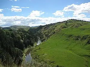 The Waikari River near Putorino | |
 | |
| Etymology | Maori meaning "dig for water" |
| Native name | Waikari (Māori) |
| Location | |
| Country | New Zealand |
| Region | Hawkes Bay |
| Settlements | Putorino |
| Physical characteristics | |
| Source | Maungaharuru Range |
| • coordinates | 39°5′50″S 176°48′21″E |
| • elevation | 780 metres (2,560 ft) |
| Mouth | Hawke Bay |
• coordinates | 39°10′8″S 177°5′23″E |
• elevation | 0 metres (0 ft) |
| Length | 49 km (30 mi) |
| Basin features | |
| River system | Waikari River |
| Waterfalls | Shine Falls |
History
In the 1931 earthquake a tsunami hit the river mouth, leaving fish up to 15 metres above the high tide level.[3]
Flooding of the river during Cyclone Gabrielle destroyed the State Highway 2 bridge over the river at Putorino.[4]
See also
References
- "Place name detail: Waikari River". New Zealand Gazetteer. New Zealand Geographic Board. Retrieved 12 July 2009.
- "1000 Māori place names". New Zealand Ministry for Culture and Heritage. 25 March 2021.
- "Tsunami – Hawke's Bay Emergency Management Group". www.hbemergency.govt.nz. Retrieved 10 March 2016.
- Moore, Heath (15 February 2023). "Cyclone Gabrielle: Frightening moment bridge bends, breaks away from road in seconds". Hawke's Bay Today. Retrieved 18 February 2023.
- New Zealand 1:50000 Topographic Map Series sheet BH39 – Putorino
This article is issued from Wikipedia. The text is licensed under Creative Commons - Attribution - Sharealike. Additional terms may apply for the media files.